PST Watershed Oversight News & Updates
Community Info + Important Updates regarding weed treatment, lake cleanup, and notice of lake hazards for PST Riparians and Visitors

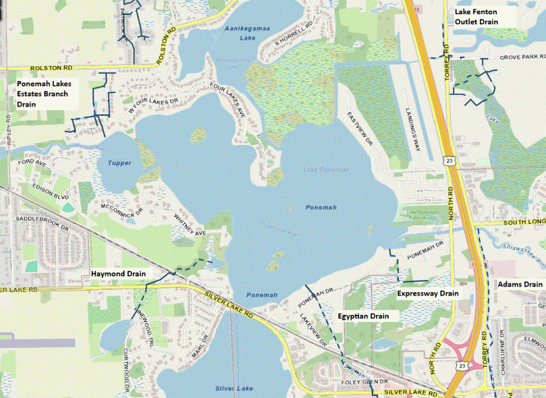
This map shows the PST Lake System and the associated County Drains.
To view an interactive map of visit the Genesee County Drain Commission Website - www.gcdcswm.com/maps/index.php
Over the course of 2026, the Water Quality committee will be placing reviews of basic lake ecology on the PST website for information purposes.
The content and images are courtesy of the Michigan State University Extension Introduction to Lakes Online Course, and included here with permission.
The articles are written by Board Liaison and Committee Member, David Bloom.
Enjoy!
PART ONE - INTRODUCTION TO LAKE ECOLOGY
There are approximately 11,000 inland lakes over five acres in size within our great state. These are home to 129 species of fish native to Michigan. The health and sustainability of our lakes is vital not only to the environment, but to the Michigan economy as well, as 2.4 billion dollars are spent on fishing-related activities each year.
Lake ecosystems are a delicate balance between the physical, chemical, and biological properties of each lake.
- Physical attributes such as light penetration, depth, and bathymetry (underwater topography) all play important roles in the health of our lakes.
- Water clarity, which provides information about light penetration, is measured with a device known as a Secchi disk.
- Chemical properties such as the amount of nitrogen and phosphorus are also key contributors to a lake’s overall health.
- Biological aspects relate to the types of aquatic life we encounter (both what we can see and what is beyond the resolution of the naked eye).
A lake can be divided into a maximum of five zones – and these definitions help us understand a lake’s ecosystem
- The littoral zone of a lake is closest to shore, shallow and slopes down to the point where aquatic plants can survive.
- This transitions to the limnetic zone or open water, which – depending on light penetration – is divided into photic zone (where photosynthesis occurs) and deeper aphotic zones (where sunlight is insufficient for photosynthesis).
- The benthic zone is the sedimentary layer of the lake and is at the base of both the littoral and limnetic zones.

Thermal stratification is the division of the lake into vertical zones by temperature:
- Epilimnion zone – closest to the surface and the warmest
- Metalimnion zone – where there is the greatest temperature gradient drop
- Hypolimnion zone – is at the bottom of the lake and is the coldest.
During spring and fall, the three layers mix and allow distribution of oxygen throughout the water, and in winter the stratification reverses so that the coldest water is at the top. This oxygenation cycle helps maintain the fish populations.

Lakes have three main water sources:
precipitation, runoff (from the surrounding watershed), and groundwater. The geology of the surrounding land and lakeshore can impact the lake’s ability to resist pollution and invasive species. For example, Zebra mussels need calcium to build their shells and survive, with some lakeshores having more sedimentary rock such as limestone leaching calcium into the water, which allows for the Zebra mussel to thrive.

Eutrophication is one more important concept to understand
- This is the over-enrichment of water by nutrients, mostly nitrogen and phosphorus, which increases algal blooms and oxygen depletion. Eventually one can have aquatic dead zones.
- These nutrients lead to increased algae and when they die, they sink to the bottom of the lake where bacteria decompose the algae. This process uses substantial amounts of oxygen, leaving less fish to survive.
- Low oxygen concentration, in turn, allows uncoupling of phosphorus from iron, leading to increased phosphorus concentration, and a vicious cycle of increased algae blooms.
- Cultural eutrophication is the human impact on the lake, which occurs much faster than natural eutrophication. Agricultural runoff, fertilizer use, and sewage are examples of cultural eutrophication and leads to killing of aquatic life, reduced biodiversity, and decreased water quality.
Knowing these basic concepts allows us to have a better understanding of how to promote lake health and water quality.

PART TWO - LAKES AND THEIR WATERSHEDS
Introduction to the Hydrologic Cycle
A watershed's function is best understood through the water cycle.
Key processes:
- Precipitation/Snowmelt: Water falling onto the land surface.
- Runoff: Water flowing over the land surface into bodies of water.
- Infiltration: Water seeping into the ground.
- Evaporation/Evapotranspiration: Water returning to the atmosphere from water bodies and plants.

What is a Watershed?
A watershed is an entire area of land that drains water into a common water body. No matter where you stand, you are in a watershed! Smaller watersheds, like those draining to specific tributaries, combine to form larger ones, such as the entire Great Lakes Watershed!

Hydrologic Features of Watersheds
Water moves through several connected landscape features within a watershed:
- Streams and rivers
- Floodplains
- Groundwater systems
- Contiguous lakes/impoundments
- Wetlands
Wetlands
Wetlands provide crucial ecosystem services that help maintain the health of lakes:
- Fish and wildlife habitat.
- Natural water quality improvement/filtration.
- Flood storage.
- Shoreline erosion protection.
- Carbon sequestration and storage.
- Recreation opportunities.
Water Quality and Human Impact
Lakes Reflect Their Watershed
The physical, chemical, and biological properties of inland lakes are directly influenced by the activities and landscape of their surrounding watershed. Human activity can introduce stress on a lake, ultimately leading to adverse water quality impacts.
Water Quality and Designated Uses
- Designated uses include agriculture, industrial water supply, public water supply, navigation, total and partial body contact recreation, other indigenous aquatic life and wildlife, fish consumption, warmwater fishery and cold-water fishery.
- Each use is evaluated for safety and if not (e.g. high E. coli and swimming / partial body contact), then it is labelled an impaired water body for that designated use.
Point Source vs. Nonpoint Source Pollution
- Point source pollution comes from a single, identifiable source, such as a factory or a sewage treatment plant pipe. These sources are regulated and require permits.
Many communities (like ours) have storm drains that collect this water and drain it directly into lakes and rivers. Failing septic systems, of which an estimated 10% are failing in Michigan, contribute to elevated levels of nitrogen, phosphorus, and bacteria.
- Nonpoint source (NPS) pollution comes from many diffuse sources and is caused by rainfall or snowmelt runoff. It is generally not regulated and is difficult to manage. The EPA states that NPS pollution is a leading cause of water quality problems.
Examples of Nonpoint Source Pollution
Runoff carries various pollutants into waterways:
- Fertilizers can introduce excess nutrients.
- Oil and grease don’t mix with water!
- Sediment
- Bacteria and nutrients
Nonpoint source pollution is particularly difficult to manage because it comes from everyday activities spread across the entire watershed, with storm drains often collecting this runoff and sending it directly into lakes and rivers.


Impact of Land Cover
Land cover significantly affects runoff rates. Replacing natural ground cover by impervious surfaces – like pavement and rooftops due to development – increases the volume and speed of runoff dramatically. This increased, rapid runoff picks up more pollutants and causes greater water quality issues compared to natural, vegetated landscapes that allow for more infiltration.
The state’s Nonpoint Source Program aims to restore impaired waterbodies and protect high quality waters through technical assistance, grants, and public education.
Point Source vs. Nonpoint Source Pollution
The primary difference lies in how easily the pollution origin can be identified and regulated.
Feature Point Source Nonpoint Source
Source Type Single, identifiable source Many diffuse sources
Regulation Regulated by the state; requires a permit Not regulated
Cause Direct discharge (e.g. pipe) Caused by rainfall or snowmelt runoff
Examples Factories, sewage treatment plants Fertilizers from lawns, oil/grease
from lots, sediment, failing septic systems
Wetland Loss
Wetlands play a vital role in water quality improvement, flood storage, and erosion protection. The functions of a wetland depend on complex relationships within the entire watershed ecosystem, highlighting how changes in one area affect the whole system.
Watershed planning
The Michigan Department of Environment, Great Lakes and Energy (EGLE) runs the Nonpoint Source program and provides technical assistance, public education, and grants to address water quality concerns. Shoreline surveys are used to assess shoreline erosion and severity, seawalls and shoreline vegetation, all important to a lake’s ecosystem and health.
The watershed planning process includes finding sources and causes of pollution, prioritizing restoration areas, and identifying high-quality areas for protection. Watershed plans are developed in partnership with lake associations, landowners, farmers, municipalities and state and local agencies. A best management practice is a technique used to prevent, control, or treat nonpoint source pollutants such as stormwater runoff.

Documents
PST LAKE ASSOCIATION, INC.(PSTLA, the Association) WATER QUALITY COMMITTEE CHARTER - Click here to view
Smart Shorelands: Stormwater Solutions for Protecting your Waterfront (Michigan State University Extension) - Click here to view
Ponemah, Aanikegamaa, and Tupper Lakes - 2026 Permit Authorization - Click here to view
